Monday, February 20, 2012

CALIFORNIA CRUISIN'- a road trip

After picking up the hire car we headed south towards Monterey Bay. It was mostly freeway driving & not particularly interesting although there were some nice views towards the end.

Decorative front on the old theatre in Monterey
Next morning we tried to get an early start so after a very uninspiring breakfast at the motel we headed off on a coastal drive called '17-Mile Drive' which ran around the headland, past some lovely scenic spots, multiple golf links (as distinct from golf courses as links are built on sand dunes) including Pebble Beach, even we have heard of this one.

Spanish Bay, this is where we saw the sea otter & loads of harbour seals
The actual lone pine, used in the Pebble Beach company logo, 250 yrs old
Eventually we ended up at Carmel & before you ask, no we did not see Clint Eastwood! Carmel is a strange sort of place there are no street numbers & your address is just east or west, north or south of the town centre....weird, I would hate to be a postie here.

This is Bird Rock, so named for the hundreds of birds that call it home,
but those darker lumps on the top are hundreds of seals

So by about 9.30am we were on our way south on the famous California Highway No 1. The views were amazing, cliff edges, gagged rocks, vertiginous bridges & some wonderful wildlife.

One of the concrete arch bridges built in the 1920s,
there are at least a dozen just like this one

This gives you a good idea of the whole stretch,
absolutely wonderful!

Getting a  feel for the steepness of the cliffs, no guard rail on the road
....aaaahhhhh!
We arrived in Morro Bay about 4 pm with just enough light left to have a wander round the town centre, to walk along the embarcadero & look at the marina. It was well & truly dark by the time we got back to our motel room. It is a really lovely town with a huge volcanic rock in the bay connected by a sand spit & a fishing fleet. There were lots of fresh seafood restaurants here but the hiccup is that some fool thought it was a good idea to build a power plant right next to the town with three chimneys.

Just to show where we were, on the famous Highway 1, no we didn't cycle it!!

Dusk at Morro Bay with the granite 'island'
We drove over the Coastal Ranges the next morning & through the fruit growing areas with views of the Sierra Nevada snow-capped mountains off in the distance. We passed through a couple of lovely townships, naturally we stopped at the fire stations & had lunch at a typical US Diner with red checked tablecloths & old movie posters decorating the walls.
 
Chips with that, Sir


Visalia, one of the beautifully restored buildings in the old downtown area
We arrived at Three Rivers mid-afternoon & after a cuppa in our motel room we headed up to the entry gate to the Sequoia National Park to check out the requirements for travelling in the area the next day, snow chains weren't required but part of the road we wanted to use was closed until April so we needed to rethink our plans.

A section of sequoia marked to show the growth rings, Paul Bunyan thrown in for fun
It was a very winding trip on a narrow road up to 7000ft in the Sequoia National Park but it was worth it to see the giant sequoia trees. They are truly majestic & superlatives fail me to describe their size. The largest living tree on earth, the General Sherman Tree is here & it is honestly absolutely huge, not the tallest but by sheer volume it outstrips all others. It is thought to be 2,700 years old, they cannot actually see the rings of course but they calculate the age based on the rings in younger trees that have been felled or have fallen & the circumference of the living tree.

Entrance sign

General Sherman Tree

There was even a little bit of snow to make it even prettier. On the road there were loads of opportunities for panoramic views that on a clear day would surely extend to the Pacific coast.

Cross-section of a fallen sequoia, just a little one, 1700 years old
Unfortunately the highway through the park was closed due to road works so we had to do a bit of backtracking & drive up another river valley to get to the other end of the road. This lead us to Kings Canyon National Park which also has amazing stands of these incredibly old trees. At this end we saw Grant's tree, well it is actually General Grant's Tree, again a massive tree, with the largest circumference. In this grove there was a fallen, hollowed out trunk that has remained unchanged for 200 years (tannins in the wood make sequoias resistant to fungi, rot & insect damage), it was used by pioneers as a shelter, stables, a pub & shop. A quick 50 mile drive & we were in Fresno for the night.

General Grant actually

Had to stand back quite a way to get this
all in one shot
View from 7000 ft
On the road again the next day! This time to the famous Yosemite National Park, it was about a two hour drive to the entrance gate from our hotel. The granite cliff faces & meadows in the valleys make this area so pretty even in the winter when most of the trees are leafless.

A roadside view

Granite cliffs of Yosemite
We were fortunate that several of the waterfalls were flowing, they are naturally much larger in the spring melt but it was great that we were able to see them running at all. We seemed to be pulling over for a photo opportunity almost every five minutes, it is a wonder we made any progress at all. We visited the Anwashee Hotel, built in the 1920s of stone & timber, it is beautifully decorated with native american flooring patterns, friezes along the cornices, art works in the store & plateware in the restaurant.

Granite cliffs & waterfalls....perfect combination

Stone & timber, perfect combination, Anwashee Inn
At the tourist information centre there was a 30 minute documentary film on the early years & the people who helped save this special area for future generations. After the movie we popped into the Native American Museum, lots of great original baskets, clothing etc. Just to make it extra special there was a little, old lady (no not me, she was native american) was making a beaded basket, she told us it had taken her a year, on & off, to get to this point as she only uses traditional methods & selects, dries & treats all her twigs, reeds etc.

Just to make us feel comforted
Had to get a few miles under our belt next day but it was a scenic trip through 'Gold Country' where in 1846 gold was discovered in California, naturally starting the gold rush. Numerous 'cute' western style towns, gorgeous river & lake scenery, more history than we could keep track off....such as Mark Twain's short story being written about the frogs in Angel Camp in 1865. We spent an hour in the middle of the day wandering round the township of Sutter Creek & talking to the lady in the tourist information office. No gold these days but liquid gold in the form of vineyards & wine is slowly bringing the area back to life. With Sacramento only about 50 miles away & San Francisco & Reno a couple of hundred it is becoming quite the 'Hunter Valley' of the San Joaquim valley.

Take away the car & replace it with a horse & you have an old western movie
We had initially planned to take one of the mountain routes to Lake Tahoe but that plan fell in a heap when they closed two of our options & made the other choice suitable for snow chains only. So we had to settle for Highway 50 which, as it turned out, was a pretty good choice. The scenery was lovely with pine forests all round, steep-sided river ravines, granite boulders with a smattering of snow as we rose slowly beside the South Fork of America River (that's the one where they actually found the first gold) to 6000' where a vista of Lake Tahoe opened up before us as we drove over the ridge. Much more snow at this altitude but not enough to close the roads which were clear & dry so nice & safe for we amateur snow drivers.

Lake Tahoe, a sandy beach with snow on it...there is a first time for everything

We awoke to a glorious fine & sunny day in our gorgeous motel room, talk about striking it lucky, they upgraded us into a king room with small kitchenette & gas-fired wood fireplace, it was so homey. Up we went in the gondola from Heavenly Village to the top of the ski hill. The first stop was an elevated platform/walkway that encircled a rock outcrop, from here we got magnificent views over the entire lake.

Lake Tahoe panorama, taken from the scenic platform

Emerald Bay with its little island, most winters this would be under snow
We enjoyed our scenic drive around the western edge of Lake Tahoe, stopping at all the vista points to enjoy the scenery. This road lead us to Tahoe City where we naturally called in to the Fire Station. We passed many wonderful snow covered building, mostly timber or stone or a mixture of the two & all fitting beautifully into the surrounding forest. It was definitely unusual to have an area with both beaches & ski slopes within 500 metres of each other.

Truckee township, where are the horse & buggies?
After Tahoe we headed directly north to Truckee, we had passed through here on the train trip but it was lovely to be able to have a better look. The town has a fabulous 'old frontier' type main street. From here we followed Interstate 80 through Donner Pass, again we travelled through here in the train but it was lovely to have a different perspective this time. 

The exterior of the covered bridge, with its thousands of wooden shingles


Inside the covered bridge....still sturdy after 150 years

Heading west we turned off the main drag at Nevada City & went bush a bit, to see a piece of history.....the longest clear span covered wooden bridge in the world. Remember the Bridges of Madison County, well it is one of those but it is 233' long & was built in 1862. Regretfully it is closed to traffic now because of safety concerns but it is still an amazing structure, the beams are huge & it is still as solid as a rock. The exterior is covered with wooden shingles.

Clear Lake, the largest fresh water lake in California,
apparently great fishing here too


Crikey...the animals you see grazing here are huge!
From the bridge it was a winding drive through the mountains to get to our next night's accommodation in Yuba City. The route from Yuba City to Leggett the start of the top half of Coastal Highway 1 was uneventful, mostly just rolling hillsides & valleys but we did travel along beside Clear Lake for a while. This is the largest natural lake in California with a shoreline of over 100 miles. Early on in our trip we drove through the orange growing centre of the state but today at a higher latitude we went through the apple, pear & walnut centres, there was a town named Williams & one named Bartlett too.

We spent the night at Leggett in a motel with no TV, radio, cellphone reception or internet - definitely off the highway now! Late in the afternoon, just before closing time we made a quick trip to the Chandler Tree, a giant coastal redwood (they are a type of sequoia too) but rather than gigantic trucks these are the tallest tree in the world. Anyway the Chandler tree is a 'Drive Thru' tree with a road that goes right through the archway that was carved in the base of the tree. Who cut it out & why they would do that I'm not sure, but it certainly has novelty value.

That is Grant in our hire car, just had to
 push in our wing mirrors
Off down the coast Highway 1 towards San Francisco next & what an amazing trip it turned out to be! The road hugs the cliff edge for a hundred miles or more (must say it was nerve racking to be the passenger as travelling south I was on the cliff side).
 
Beautiful rock formations in the stormy seas

There were plenty of these, both
arriving & leaving
We stopped half way along the journey at Timber Cove Inn, a gorgeous weathered-timber hotel clinging to the clifftop for the night. Continuing the following morning along, what turned out to be even more terrifying cliff edges. In the passenger seat on the ocean side with no safety rail I was closer to the edge than I would normally go at a lookout. So terrifying, I had to shut my eyes for long stretches opening them when Grant pulled into a 'turn out' as they call them here to enjoy the views. The ocean was quite wild with waves crashing round the off-shore rocks, there were tunnel/arch rocks everywhere & what sand there was, was black volcanic. 

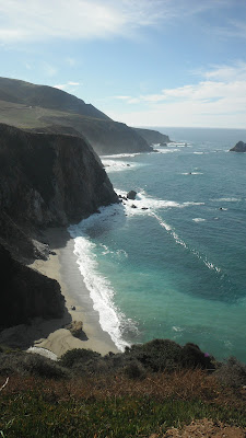
Glorious vistas from the roadside

This area is famous for its whale watching during the winter months but unfortunately we didn't spot any, just hundreds of seals sunning themselves at the mouth of the river at Jenner. Just south of Jenner there was a cliff edge that I had just bought a postcard of, anyway it doesn't look anything like the postcard now, where there used to be twenty luxury homes now there was just crumbling cliff face, they had all been claimed by the sea. All that remained was a few pylons that had been the footing & foundations of the mansions overlooking the Pacific. The cliff was almost back to the road, guess they will have to relocate the road too eventually. It was dumbfounding to hold the postcard in one hand & to look at the current situation at the same time.

Mouth of the river at Jenner,
can you see the seals on the sand near the channel?


There used to be a row of mansions along that cliff top, before the sea
reclaimed them
Another seaside spot we drove though was Bodega Bay, made famous in the Hitchcock movie 'The Birds', pretty spot with a marina/harbour full of very expensive boats & yachts. Turn left, travelling inland & we were on the last step of our two week trip, driving through dairy farm country till we got to Santa Rosa. From here it was just a short drive to take the car back & catch the train to Portland, Oregon.

Wednesday, February 8, 2012

CALIFORNIA DREAMIN'

San Francisco

Lovely sunny day, sorry about the squinting but the perfect shot to start the blog!

Our first full day was packed but at a lovely relaxed pace. We walked down to Fisherman's Wharf then along the 35 piers until we got to the main street into the city centre. Then into the city centre to the Tourist Information Office. The locals are so friendly here, every time we stopped to look at a map someone offered assistance, it is so lovely of them.

Harbour seals making themselves comfortable at the pier


'Riding' the historic cable cars, this one was
actually stationary but you are allowed to
ride on the side
To finish off our day we caught the historic cable car, after watching the staff manually push it round using the wooden turntable, to the top of Lombard Street & walked down the 'crooked street'. We have all seen it in a dozen movies, I even have a jigsaw puzzle of it. Being winter, the gardens were nothing special but the staircase down the side (you're not actually allowed to walk on the road & who would want to - it was full of cars) was crowded with people going in both directions.

Lombard Street, the most crooked street
in the world & the star of many a movie!
It is prettier in Spring with lovely flowers
decorating the zigzags
We had set Saturday aside specifically to walk the Golden Gate Bridge. First we caught a bus to the lookout area on the southern side (where the bus turns round) & we joined the other 'million or so' people walking, running, rollerskating & cycling. The views were amazing, the wind was cold, the bay was full of sailing boats in some sort of regatta & the crowds were a nightmare. The crowding was made worse by the fact that one of the two pedestrian walkways was closed for renovations.
 
View from the footpath up into the rigging

Panorama taken from the centre of the bridge, Alcatraz Island in the centre of the bay, city skyline on the right
There was no access to a bus on the other side, not that we could find anyway, so we walked back! The distance wasn't that great only a couple of kilometres & although you go up in the centre it is a very gradual rise. Bus back to near home then we walked along Union Street shopping strip, some really great shops here but I kept my purse firmly locked in my shoulder bag. This district is called Cow Hollow & there were plenty of lovely painted Victorian style homes around that had survived the fire of 1906.

Renovated Art Deco theatre in Cow Hollow
The rest of the week was go, go,go so I thought I would list some of the main things we saw or did:
Alcatraz Island tour,
A cell, bed with metal slat base, toilet,
basin & a shelf that's about it

Guard's Tower
Numerous trips round, across, over & under town in the cable or trolley cars,

Such fun, it was like riding the big dipper with the man behind you
 operating the brakes which is the only control they have
Wells Fargo & the Pony Express Museum & all the wonderful memorabilia they had on display,

An actual stagecoach from the 1800s

The Embarcadero which is really a boardwalk along the piers many of which have been renovated,

Historic buildings, including this market, line the embarcadero & piers
Golden Gate Park with its Japanese Tea Gardens, lake with paddle boats & art galley,


Haight Street made famous in the '60s as the home of the 'Flower Power' revolution & still full of hippies & alternative lifestylers, 

Shop signs are a give away to the type of community this is
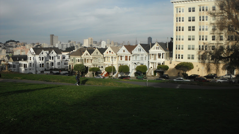
Painted Ladies of Alamo Square, they are the gorgeous Victorian mansions which have survived earthquakes & fires & are as pretty as ever,

Ladies all lined up with the city skyline in the background

An example of the architectural features
on the homes round Alamo Square
Coit Tower built on the top of Telegraph Hill with money bequeathed to the city (You guessed it, by the Coit family) for beautification projects,

Coit Tower, 64 metres tall
A T & T Baseball Park tour, even though we know nothing about the game it was interesting to tour the facilitiy & see the pitch, dug-outs, sponsors boxes etc,

Getting the pitch ready for the upcoming season
Fisherman's Wharf, Pier 39 with its resident seals, trolley cars that run underground through the main city area, amazing city buildings,
Flat-iron shaped building, one of several
built around the early 1900s

Four clocks, four water fountains
& four lights on top, sorry couldn't
fit it all in the one shot!
San Francisco is a great spot for a holiday, plenty to see & do but the city is small enough to be able to walk lots, plenty of fresh air & sunshine (bit foggy though if you get up early), a happy mix of old & new buildings & residents.  Off on the road for about a fortnight now.....

Wednesday, February 1, 2012

CALIFORNIA ZEPHYR - a journey to remember with Amtrak

Buffalo - bit of a surprise package 

We left Toronto on the 8:20 am train & after the trip to the border near Niagara Falls & almost two hours spent getting the passengers & train cleared through US customs we finally left the border control area and were on our way to Buffalo.


For some unknown reason the main Amtrak station is way out of town so we caught a taxi into the city & buses back later in the evening. The Fire Station was first job as it was easy to find in the heart of the city then we found the tourist information office. They offered a short film on the architectural highlights of the city which are more extensive than we ever imagined, then we headed off on a suggest walk round the downtown area.

Entrance to the Tourist Information Office
Buffalo has been a huge boomtown in the late 19th & early 20th centuries so there are some outstanding examples of buildings designed & constructed by America's most famous architects as well as a wonderful city layout with parks lining the main accessways. In more recent years they have introduced a free city tram that runs up & down the main pedestrian street which not surprisingly, is called Main Street.

Main Street, downtown Buffalo

Lovely 4-faced cast iron clock
When it started to sprinkle we were more than happy to go into one of the city's most famous buildings for a bit of a squizz. It was the City Hall, very grand looking art deco structure completed in 1931, it has the most magnificent foyer with murals, brass door decorations, carved door frames (each one completely different), marble floors with brass inlays & vaulted ceiling with mosaic decorations. On the 28th floor there is an observation level with both indoor & exterior viewing areas, since it was raining we naturally stayed inside & contented ourselves with seeing Lake Eirie & the Niagara River through the glass.

City Hall, we went to the top floor lookout

Close-up of the top section of City Hall,
Can you see us?

One section of the wonderful view, you can see Lake Erie & the mouth
of Niagara River, despite the miserable weather, still marvelous
Once it got dark it was time for us to 'grab some chow' & get back to the railway station to await our midnight departure. We had chosen to sit up for this overnight section of the trip, not only to save money but also because it was really only half a night with the late boarding time & we felt that was manageable. The seats proved to be quite comfortable with miles of leg room & a foot rest like a Lazy-boy chair. 

Next stopover was just four hours in Chicago....

Chicago - named after a stinky marsh weed, how inspiring is that?

We had a bit of a plan for Chicago which fortunately for us worked like a charm. Firstly, the train needed to be on time at 9:45am.......fantastic, that happened, in fact we were even a few minutes early. Secondly, we needed to find baggage storage or luggage lockers quick smart, done! Next we needed to get out of the Union Station complex & up onto street level then cross the river & find our way to the bottom of the Sear's Tower (now known as Willis Tower) to catch a tour bus which was due to depart at 10:00am.

Our first view of the tallest building in the
world from outside Union Station, Chicago
Made it easily, only because the tour bus was running a bit behind schedule!! The tour was expected to last about two hours but actually took two & a quarter hours which didn't leave much time for the other things we needed to do. 

A small section of the city skyline

Theatre made famous by Frank Sanatra
On our tour we were pleasantly surprised at how pretty the city was, I have always imagined Chicago to be a bit 'industrial' but it is so much more than that. Being on the banks of Lake Michigan probably adds to its reputation as the windy city but also gives it great sandy beaches, lots of marinas & water sports in the summer & very expensive apartments with views to Canada.

Lakeside view with a bit of the skyline too

The El, elevated railway line that runs through the city
The word skyscraper was first coined in Chicago in 1885 when the first one was built, you get a crick in your neck just looking at the different architectural styles. After the big fire of the late 1800s there were only a few of the original structures left standing, these had been built of limestone (a couple of churches & the water pumping station to name some pointed out on the tour) so needless to say withstood the inferno which burned for two days. After that there was a construction boom & once Mr Otis perfected his elevator & they designed buildings with non-loadbearing walls there was no stopping the height to which structures could soar.
Gives you a nose bleed just looking up
One amazing thing they did here was to reverse the flow of the Chicago River in 1900 so that the water flowed into the Mississippi drainage basin rather than Lake Michigan. The pollution pouring into the river & subsequently into the lake was causing disease as all the city's drinking water came & still does come out of the lake.
Section of Chicago River as it flows through the city
Some of the iconic places we recognised were: Seare's Tower which was renamed in recent years to Willis Tower, John Hancock Building, Trump Tower, Soldier Stadium (home of the Chicago White Sox baseball team), LSD (Lake Shore Drive, the tour guide said that joke was funnier in the '70s), Wrigley Building & Wrigley Field.
Gigantic Marilyn Monroe fibreglass public art piece & in the glass building
behind you can see a reflection of another building
Old combined with new - the original stadium with its spaceship addition on top
Our time was nearly up on the locker so I went back to the station to get our luggage & Grant zipped off to the fire station he had found in the centre of the city. All went very smoothly & we got to the departure lounge for our train just as they started calling the train number. Because this part of the trip involved two nights we chose to pay the extra & to have a sleeping compartment. This ticket included meals & a few extras but most importantly a small room with two armchairs & a table which converted into double bunks, such a gentleman - Grant took the top bunk.

Enjoying a bit of late lunch in our cabin
after our busy stop-over in Chicago

Last stage of the journey

Our little sleeper compartment on the train is so cute & really comfortable, we also had access to the skyliner lounge with its glass roof. The food which was included in the ticket price were delicious & we had quite a good choice too. The staff were lovely & really helpful, they couldn't do enough for you, coffee, juice & iced water on tap in our carriage, daily newspapers slipped under our door. What surprised us was that the cost was virtually the same as the cost of a flight!

Sightseer Lounge, enjoying the view

We passed lots of great scenery of course but it's worth mentioning was that we crossed the Mississippi River as we moved from Illinois to Iowa & then the Missouri River as we progressed from Iowa to Nebraska. We travelled through four time zones & the first change came at the Colorado State Line.

Ice flows in the Mississippi River

Denver was one of the refuelling stops, it is known as the Mile-High City because it is one mile high when measured at the 13th step of the capitol building. The altitude caused many a 'popping' ear on this trip as we went up & down several times. Outside Denver we negotiated 'Big 10 Curve' a spot where the winds are so strong that they have welded rail cars to an adjoining track & filled them with sand to act as a windbreak. As we rise up the plateau we got great views back over Denver.

As you can see we climbed to 9,000 ft, an ear-popping experience
We went through Moffat Tunnel which is 6.2 miles long & cut 176 miles off the journey & as we came out the other side we were greeted with a beautiful snowy vista, Winter Park Ski Resort. This spot is considered to be the 'Icebox of America' with winter temperatures down to -50 degrees Farenheight. But very pretty never the less!

Winter Park, beautiful sight
The next section of our journey took us through the Rocky Mountain National Park with its steep, inaccessible gorges, magnificent vistas, raging rivers & isolated towns with rich histories.  We went through towns with such history as:  Butch Cassidy & the Hole in the Wall gang robbed the bank, gold rushes, home of Caterpillar, Hog Capital of the World, home of the Amazon Distribution Centre, underground coal seams that have been burning since 1888, passed glacial lakes, Reno the divorce capital of the world, so many interesting things it is impossible to mention them all.
 
Checking out Fraser Canyon through the roof

Gore Canyon, absolutely lovely, you cannot see this area unless you
are on a train or a kayak - no road access - Class V whitewater,
the wildest available in the state

Cannot miss the wonderful Mesa formations near Grand Junction

Ruby Gorge, the colour was really amazing & the strata very noticeable
We also crossed the high plains of Nevada but that was at night so we didn't see much of that 'boring; scenery which was good. We did see Salt Lake City in the dark though, it was quite pretty really, very big place with a wall of mountains forming a back drop.

Reno was the next really big town & we crossed the border from Nevada into California.  Donner Lake has a sad history with a wagon train of people travelling west in 1846 being stranded by a blizzard. Of 87 who started out on the journey only 48 survived after several people walked out for help.

Donner Lake, a wild & inhospitable area I'm sure 150 years ago but now
a popular resort & holiday destination
Then on to the Sierra Nevada Ranges (that's funny I thought they were in Spain) & the trip to Sacramento, the capital of California.  The last stage was to Emeryville the station 45 minutes outside of San Francisco where you pick up a bus for the last little step.  It was great to cross the Bay Bridge skirting round the edges of the bay to bring us into the centre of the city.

The Bay Bridge from the original road looking at the new one they are building
which will run parallel
San Francisco we're here!!